
The city of Gothenburg publishes their orthophotos as open data, WMS included. The imagery was collected 1998-2021 and I wanted a simple web map where I could easily switch year and see the differences. Perhaps ChatGPT could help me with the coding?
I usually start the AI chat by asking “Hi! Are you busy?” and the answer is always no, so I asked it to provide the code for a simple Leaflet map. I provided the base WMS URL and the layer names. The result was almost spot on. Just a few tweaks later the code looked like this:
<!DOCTYPE html>
<html>
<head>
  <title>Leaflet map</title>
  <meta charset="utf-8" />
  <meta name="viewport" content="width=device-width, initial-scale=1.0">
  <!-- Add Leaflet CSS and JS -->
  <link rel="stylesheet" href="https://unpkg.com/leaflet@1.9.4/dist/leaflet.css" />
  <script src="https://unpkg.com/leaflet@1.9.4/dist/leaflet.js"></script>
  <style>
    body, html {
      margin: 0;
      padding: 0;
      width: 100%;
      height: 100%;
      overflow: hidden;
    }
    #map {
      width: 100%;
      height: 100%;
    }
  </style>
</head>
<body>
  <div id="map"></div>

  <script>
    // Create Leaflet map and set center
    var map = L.map('map').setView([57.7072, 11.9668], 11);

    // Add WMS layers
    var wmsLayerOrto1998 = L.tileLayer.wms('https://opengeodata.goteborg.se/services/ortofoto/wms/v1', {
      layers: 'orto_1998',
      format: 'image/png',
      transparent: true,
      attribution: 'Ortofoto 1998'
    });

    var wmsLayerOrto2003 = L.tileLayer.wms('https://opengeodata.goteborg.se/services/ortofoto/wms/v1', {
      layers: 'orto_2003',
      format: 'image/png',
      transparent: true,
      attribution: 'Ortofoto 2003'
    });

    var wmsLayerOrto2006 = L.tileLayer.wms('https://opengeodata.goteborg.se/services/ortofoto/wms/v1', {
      layers: 'orto_2006',
      format: 'image/png',
      transparent: true,
      attribution: 'Ortofoto 2006'
    });

    var wmsLayerOrto2008 = L.tileLayer.wms('https://opengeodata.goteborg.se/services/ortofoto/wms/v1', {
      layers: 'orto_2008',
      format: 'image/png',
      transparent: true,
      attribution: 'Ortofoto 2008'
    });

    var wmsLayerOrto2010 = L.tileLayer.wms('https://opengeodata.goteborg.se/services/ortofoto/wms/v1', {
      layers: 'orto_2010',
      format: 'image/png',
      transparent: true,
      attribution: 'Ortofoto 2010'
    });

    var wmsLayerOrto2015 = L.tileLayer.wms('https://opengeodata.goteborg.se/services/ortofoto/wms/v1', {
      layers: 'orto_2015',
      format: 'image/png',
      transparent: true,
      attribution: 'Ortofoto 2015'
    });

    var wmsLayerOrto2017 = L.tileLayer.wms('https://opengeodata.goteborg.se/services/ortofoto/wms/v1', {
      layers: 'orto_2017',
      format: 'image/png',
      transparent: true,
      attribution: 'Ortofoto 2017'
    });

    var wmsLayerOrto2019 = L.tileLayer.wms('https://opengeodata.goteborg.se/services/ortofoto/wms/v1', {
      layers: 'orto_2019',
      format: 'image/png',
      transparent: true,
      attribution: 'Ortofoto 2019'
    });

    var wmsLayerOrto2021 = L.tileLayer.wms('https://opengeodata.goteborg.se/services/ortofoto/wms/v1', {
      layers: 'orto_2021',
      format: 'image/png',
      transparent: true,
      attribution: 'Ortofoto 2021'
    });

    // Add layer switcher
    var baseLayers = {
      "Ortofoto 1998": wmsLayerOrto1998,
      "Ortofoto 2003": wmsLayerOrto2003,
      "Ortofoto 2006": wmsLayerOrto2006,
      "Ortofoto 2008": wmsLayerOrto2008,
      "Ortofoto 2010": wmsLayerOrto2010,
      "Ortofoto 2015": wmsLayerOrto2015,
      "Ortofoto 2017": wmsLayerOrto2017,
      "Ortofoto 2019": wmsLayerOrto2019,
      "Ortofoto 2021": wmsLayerOrto2021
    };

    L.control.layers(baseLayers).addTo(map);

    // Set standard base layer
    wmsLayerOrto2021.addTo(map);
  </script>
</body>
</html>
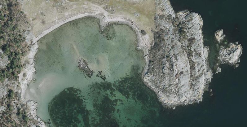
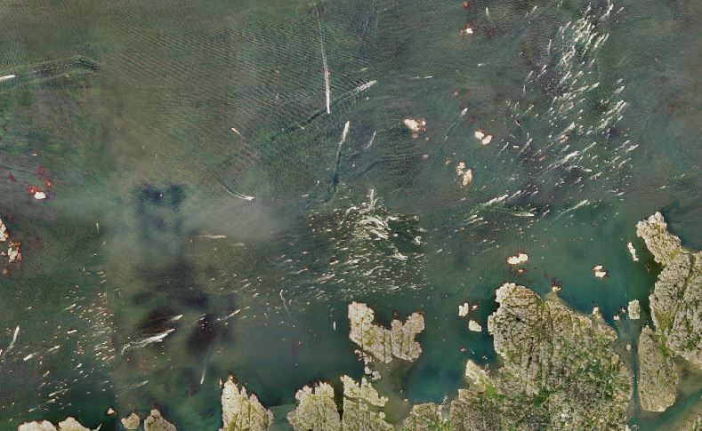
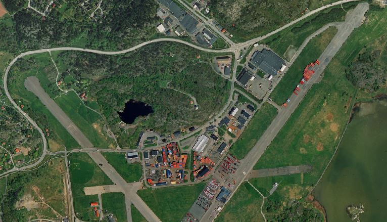
The result:
Try the fullscreen version here.
A few observations from the imagery:
But what about OpenLayers, MapLibre, CesiumJS and friends? We will of course cover them in upcoming posts.